We turn site conditions into clear data and engineering deliverables that support construction. Our work connects field surveying and technical delivery across highways, rail, cities, water and land.
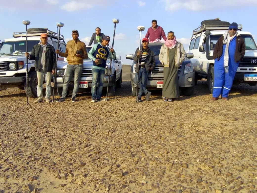
GeoGiza people and equipment in the field — from our company photographs.
3,000+
Projects across our company
6
Sectors in this selection
Connected expertise
From observations to technical delivery
EXPERTISE IN PRACTICE
Different challenges. A clear contribution.
From corridors spanning tens of kilometres to survey-control networks and extensive land datasets, these examples show how our capabilities come together.
Roads & highways
Gafgafa–Sadr Hitan
60km in the survey package
Topographic surveying and Civil 3D processing for a 60 km Sinai road section, bringing field observations and survey control into usable engineering deliverables.
Connecting site conditions with the drawings and models the project team needs.
A team that connects the site with the work ahead.
01
A clear survey foundation
Topographic surveys, control networks and coordinates connecting ground conditions with design and site requirements.
02
Support for site delivery
Setting-out, levels and coordination with contractors and consultants across roads, utilities and facilities.
03
Fieldwork and technical delivery
Civil 3D processing, quantity takeoff, drawings, digital files and GNSS equipment suited to the work scope.
DIVERSE SCOPES. ONE ENGINEERING STANDARD.
Selected work from our portfolio
Drawn from 3,000+ projects across our company, these selected examples show the breadth of our work and our role in each scope, from survey control to technical delivery and equipment provision.
Showing 38 of 38 selected examples of our work
Roads & highways
Transverse Road 1
Sinai
Surveying and technical-office support connecting ground levels, drawings, road-layer checks and quantity takeoff.
Project value
Survey data to support quantity review and roadworks coordination.
52.92km in documented quantity sheets
Our scope of work
Road levels, survey records and master sheets.
Survey-derived quantity takeoff and road-layer QA/QC.
Roads & highways
Gafgafa–Sadr Hitan
Sinai · Transverse Road 4
Topographic surveying and Civil 3D processing for a 60 km Sinai road section, bringing field observations and survey control into usable engineering deliverables.
Project value
Connecting site conditions with the drawings and models the project team needs.
60km in the survey package
Our scope of work
Delivery of a topographic and Civil 3D package for a 60 km section.
Survey-control datasets around Arady 4, Sadr Hitan and Bir El Abd.
Roads & highways
El Gady Road
Sinai
A 144-point control dataset with coordinates, elevations and scale factors supporting the road’s survey reference.
Project value
A shared survey reference for coordinating measurements across the work area.
144points in the control dataset
Our scope of work
Preparation and delivery of a 144-point survey-control dataset.
Coordinates, elevations and scale factors organised into a technical package.
Roads & highways
Oyoun Mousa–Sharm El Sheikh
Sinai
Survey and control participation along western Sinai’s coastal corridor, including review of the 80 km Oyoun Mousa–Abu Zenima section.
Project value
Survey and control data supporting the section’s technical review.
Our scope of work
Survey and control work within the road programme.
Review of the 80 km Oyoun Mousa–Abu Zenima section.
Roads & highways
Middle Ring Road
Greater Cairo
Topographic surveying and existing-ground levels for a Middle Ring Road section, with site conditions addressed in the technical delivery.
Project value
A clearer view of ground conditions for planning and reviewing the works.
Our scope of work
Topographic survey and existing-ground levels (EGL).
Field-condition limitations recorded with the delivery.
Roads & highways
30 June Axis
Egypt
Topographic and natural-ground surveying, with survey-control, source-data and raw GNSS observation delivery.
Project value
Ground and control data brought together for the road project team.
Our scope of work
Natural-ground survey and control data.
Raw GNSS observation files and source-data delivery.
Roads & highways
Shubra–Banha Free Road
Shubra–Banha
Survey-control observations for the Shubra–Banha Free Road, supporting a consistent measurement reference for the project.
Project value
A survey reference to support road measurements.
Our scope of work
Surveying of road control points.
Rail infrastructure
Electric Train · Phase 3
El Salam–New Administrative Capital
A survey-control network for Electric Train Phase 3, with a contracted scope covering installation, observation and delivery of 27 control points.
Project value
An engineering reference for coordinating measurements along the rail corridor.
27control points in the contracted scope
Our scope of work
Control-point installation, observation and delivery within the contracted scope.
This workstream relates specifically to Electric Train Phase 3.
Cities & utilities
Bin Zayed Axes & Road 11
New Administrative Capital
Survey, control and setting-out with Elsewedy across South and North Bin Zayed and Road 11, supporting road and lighting site works.
Project value
Survey work aligned with the needs of road and lighting teams.
Our scope of work
Road survey, static control, setting-out and site support.
Survey and static-control work for a 15 km section within the Bin Zayed scope.
Cities & utilities
North Mohamed Bin Zayed Lighting
New Administrative Capital
An Elsewedy work package combining survey, static control and setting-out for North Mohamed Bin Zayed Axis lighting.
Project value
Lighting locations tied to a clear survey reference.
Our scope of work
Surveying and static control for the road and lighting work area.
Setting-out to meet the survey package requirements.
Cities & utilities
R1 & R2 Utilities
New Administrative Capital
Survey control and utility setting-out within the HITEKNOFAL workstream.
Project value
Translating utility layouts into setting-out points on site.
Our scope of work
Control points and deployment of surveyors and GPS equipment.
Utility setting-out.
Cities & utilities
Cairo Festival City
New Cairo · Residential Apartments E
Survey support for Residential Apartments E, including borehole setting-out and technical delivery coordinated with the client and consultant.
Project value
Locating ground-investigation points to meet the design team’s requirements.
Our scope of work
Borehole setting-out and associated survey deliverables.
Technical coordination with the client and consultant.
Cities & utilities
Arab Investment Bank Headquarters
New Administrative Capital
A topographic scope awarded by EHAF for the bank’s New Capital site, covering site survey, borehole setting-out, printed drawings and AutoCAD files.
Project value
Preparing site information for investigation and engineering work.
Our scope of work
Awarded scope for an approximately 5,545 m² site and 10 borehole locations.
Topographic hard-copy and AutoCAD deliverables specified in the award letter.
Cities & utilities
El Rehab Survey Programme
El Rehab
Recurring topographic and as-built surveying with coordinate transformation at El Rehab.
Project value
Consistent survey references and a clearer record of existing conditions.
Our scope of work
Topographic surveys and as-built documentation.
Coordinate transformation for survey-data coordination.
Land & registration
Digital Property Registration Surveys
Egypt
From inspection to digital files: Edge-Pro survey work supporting property registration, including review and correction requirements.
Project value
Turning field measurements into reviewable deliverables for registration workflows.
Our scope of work
Field inspection and digital survey delivery.
Service-level, correction and re-survey obligations within the framework.
Land & registration
North Tahrir Cadastral Survey
North Tahrir
Cadastral surveying of North Tahrir parcels and roads, with area schedules under a direct contract.
Project value
Structured information on parcel boundaries, areas and adjoining roads.
Our scope of work
Parcel and road surveying with area schedules within the contracted scope.
Water & environment
Helwan Waste-Management Facility
Helwan · Cairo
Surveying, Civil 3D and excavation-quantity support, coordinating roads, ramps and facility elements.
Project value
Connecting site levels with excavation quantities and facility setting-out.
Our scope of work
Site levels, excavation quantities, and road and ramp coordination.
Evaporation-pond survey and setting-out, plus incinerator-platform support.
Survey equipment
ARDISEIS / ARGAS
Egypt
Survey-equipment and GNSS rental and provision for ARDISEIS / ARGAS, supporting the client’s field-equipment needs.
Project value
Access to survey equipment suited to field-team requirements.
Our scope of work
GNSS and survey-equipment rental and provision.
Equipment-requirement coordination with client teams.
Land & registration
REGWA Survey Works
Egypt
Parcel and road surveys with coordinate and area schedules, connecting fieldwork with land-management needs.
Project value
A structured reference for land boundaries and areas.
Our scope of work
Surveying of parcels and associated roads.
Coordinate and area schedules within the collaboration framework.
Land & registration
New Valley Land Regularisation
Farafra · Kharga · Dakhla
Surveying and data processing for New Valley land, within a scope covering 2,375 regularisation applications across Farafra, Kharga and Dakhla.
Project value
Organised survey data to support land-regularisation file review.
2,375applications in the data scope
Our scope of work
Processing and consolidation of survey data for regularisation applications.
Land-data coordination across the three work locations.
Cities & utilities
Badr Cooperative Housing Land
Badr City
Surveying, subdivision and parcel setting-out within the roads and earthworks scope for Badr’s cooperative housing land.
Project value
Translating subdivisions and coordinates into usable site setting-out points.
Our scope of work
Parcel subdivision, setting-out and coordinates.
Survey support within road and grading works.
Water & environment
Sinai Water Pumping Station 1
North & Central Sinai
Topographic and grid-level surveys with quantity support at the pumping station, providing survey input for site-level coordination.
Project value
Connecting ground details with work levels and quantities.
Our scope of work
Topographic survey and detailed grid levelling.
Quantity-survey input and support for the site team.
Water & environment
Sinai Water Pumping Station 2
North & Central Sinai
Topographic and grid-level surveys with quantity support at the pumping station, providing survey input for site-level coordination.
Project value
Connecting ground details with work levels and quantities.
Our scope of work
Topographic survey and detailed grid levelling.
Quantity-survey input and support for the site team.
Water & environment
El Saff & Minya Wastewater Stations
El Saff · Minya
A wastewater-station survey package combining control points, grid levelling, elevations and earthworks deliverables.
Project value
Site information to support excavation, fill and structure coordination.
Our scope of work
Control points, baselines and grid-level surveys.
DWG drawings, levels and cut-and-fill outputs.
Roads & highways
Shaq El Thoaban Road
Shaq El Thoaban
Topographic and grid-level surveying for the Shaq El Thoaban road, within a 14.34 km scope.
Project value
Ground details and levels to support the road works.
14.34km in the road scope
Our scope of work
Topographic and grid-level survey of the road corridor.
Cities & utilities
GAMA Survey Services
Egypt
A surveying assignment with GAMA within the company’s work with construction and engineering teams.
Project value
Professional coordination around survey-service requirements.
Our scope of work
Survey services within the GAMA assignment.
Rail infrastructure
Adly Mansour–Robiki Corridor
Adly Mansour · Robiki
Participation in civil works and earthworks for formation layers along the Adly Mansour–Robiki rail corridor.
Project value
Contributing to formation-layer preparation for the transport corridor.
Our scope of work
Civil works and earthworks for the assigned formation-layer scope.
Cities & utilities
COMAG International School
Egypt
Recurring survey support for COMAG’s international school project, covering levels, control points and shop drawings.
Project value
Field measurements connected to drawing and construction-team needs.
Our scope of work
Level surveys and control points.
Survey outputs supporting shop drawings and site work.
Land & registration
El Dabaa Survey Control
El Dabaa
GNSS control-point establishment and processing in El Dabaa, providing a coordinate reference for associated surveying work.
Project value
An organised coordinate reference for subsequent surveying.
Our scope of work
GNSS observations and baseline processing.
Survey-control point data preparation.
Water & environment
GRE Water-Injection Pipeline
Egypt
Route surveying and plan-and-profile drawings for a GRE water-injection pipeline, connecting alignment with ground levels.
Project value
A clear relationship between pipeline alignment and changing ground levels.
Our scope of work
Water-pipeline route survey.
Plan-and-profile drawing preparation.
Cities & utilities
Red Sea Fuel Stations
Red Sea
Surveying of two fuel-station sites, covering boundaries, coordinates, grid levels and contour maps.
Project value
Topographic site information to support engineering planning.
Our scope of work
Boundary and coordinate surveys for both sites.
Grid-level surveys and contour maps.
Cities & utilities
Hatoor · Lotus Restaurant Complex
Egypt
Survey support for the Lotus restaurant complex, centred on site coordinates and coordination with the project team.
Project value
A coordinate reference to support site coordination.
Our scope of work
Site coordinates and associated control-point data.
Survey coordination with the project team.
Water & environment
Manial Sultan Wastewater Plant
Atfih · Giza
A contracted scope to establish four GPS control points at Manial Sultan wastewater plant, supporting the site’s survey reference.
Project value
Establishing a survey reference for the plant within the contracted scope.
Our scope of work
Establishment of four GPS points under the contracted scope.
Cities & utilities
Stone Park
Egypt
Existing-condition surveying with coordinate and observation-data delivery for Stone Park’s survey requirements.
Project value
Field documentation supporting site understanding and coordination.
Our scope of work
Existing-condition survey and coordinate delivery.
Survey-observation file preparation.
Land & registration
New Capital · 1,000-Feddan Area
New Administrative Capital
Natural-ground surveying for the area known as the 1,000-Feddan Area, with coordinate and elevation deliverables for development work.
Project value
Natural-ground information as a basis for investigation and planning.
Our scope of work
Natural-ground level surveying.
Coordinate and elevation preparation and delivery.
Land & registration
Abu Zenima Industrial Land
Abu Zenima · Sinai
Surveying and control for Abu Zenima industrial land, with coordinate preparation across multiple projection systems.
Project value
Survey information aligned with the project’s coordinate-system requirements.
Our scope of work
Control points and survey outputs for the industrial land.
Coordinates in UTM, Blue Belt and ETM systems.
Cities & utilities
Sheikh Zayed Survey Works
Sheikh Zayed · Area T
Surveying in Sheikh Zayed’s Area T, combining coordinates, elevations, drawings and observation files.
Project value
Digital deliverables connecting field measurements with site drawings.
Our scope of work
Surveying and preparation of coordinate and elevation data.
DWG and survey-observation files for the work area.
Land & registration
Kayan Land Survey
Egypt
Natural-ground survey for a 140-feddan scope at Kayan, with survey-file and drawing preparation and delivery.
Project value
Survey information on ground conditions to support development needs.
140feddans in the survey scope
Our scope of work
Natural-ground survey and digital deliverables.
Survey data and DWG drawing delivery.
FROM THE FIELD
The people behind the delivery
Behind the data and drawings is a team working on the ground. See our people, equipment and field environment.
START WITH YOUR PROJECT REQUIREMENTS
Put our experience to work on your project.
A road, a facility, utilities or land development? Share your requirements so we can define the scope, deliverables and equipment for your project.