
    Egypt reference · GeoGiza review guide

    Leveling specifications in Egypt

    Read the specification, formula and evidence; choose your project grade to calculate.

    Specifications and error limits

    d is the shorter run in km; the limit checks vertical misclosure.

    Limits by work grade. Calculate using the grade named in your project.

    d: shorter forward/backward length in km. Misclosure is the absolute sum of the two signed observed height differences.

    Documented editions; currentness and project applicability need confirmation.

    I do not know the required grade

    Check the contract, quality plan and receiving authority. An unspecified grade leaves project acceptance unresolved; browse and compare limits without an automatically chosen grade.

    Calculate the limit for your work

    All rules and evidence
    Rule, formula and evidence register for this task (8)

    All rules and evidence are available without JavaScript. Read the complete provision and project conditions.

    ESA · First order, precise · double-run line

    3 × √d mm

    d: shorter forward/backward length in km. Misclosure is the absolute sum of the two signed observed height differences.

    Use the grade specified for your project and consult the complete provision for instruments, rods, calibration and control ties.

    Technical specifications for surveying and mapping — surveying

    Egyptian Survey Authority · First edition 2020

    Chapter 2 · 3-1 · Table 2-13 · printed 33 · PDF 54

    Open the official evidence page

    Edition/provision checked: 2026-10-12 · Currentness and project applicability need confirmation.

    ESA · First order, precise · loop

    4 × √E mm

    E: sum of loop-section lengths in km. Closure uses backsight/foresight totals and known start/end elevations.

    Use the grade specified for your project and consult the complete provision for instruments, rods, calibration and control ties.

    Technical specifications for surveying and mapping — surveying

    Egyptian Survey Authority · First edition 2020

    Chapter 2 · 3-1 · Table 2-13 · printed 33 · PDF 54

    Open the official evidence page

    Edition/provision checked: 2026-10-12 · Currentness and project applicability need confirmation.

    ESA · Second order I · double-run line

    4 × √d mm

    d: shorter forward/backward length in km. Misclosure is the absolute sum of the two signed observed height differences.

    Use the grade specified for your project and consult the complete provision for instruments, rods, calibration and control ties.

    Technical specifications for surveying and mapping — surveying

    Egyptian Survey Authority · First edition 2020

    Chapter 2 · 3-1 · Table 2-13 · printed 33 · PDF 54

    Open the official evidence page

    Edition/provision checked: 2026-10-12 · Currentness and project applicability need confirmation.

    ESA · Second order I · loop

    5 × √E mm

    E: sum of loop-section lengths in km. Closure uses backsight/foresight totals and known start/end elevations.

    Use the grade specified for your project and consult the complete provision for instruments, rods, calibration and control ties.

    Technical specifications for surveying and mapping — surveying

    Egyptian Survey Authority · First edition 2020

    Chapter 2 · 3-1 · Table 2-13 · printed 33 · PDF 54

    Open the official evidence page

    Edition/provision checked: 2026-10-12 · Currentness and project applicability need confirmation.

    ESA · Second order II · double-run line

    6 × √d mm

    d: shorter forward/backward length in km. Misclosure is the absolute sum of the two signed observed height differences.

    Use the grade specified for your project and consult the complete provision for instruments, rods, calibration and control ties.

    Technical specifications for surveying and mapping — surveying

    Egyptian Survey Authority · First edition 2020

    Chapter 2 · 3-1 · Table 2-13 · printed 33 · PDF 54

    Open the official evidence page

    Edition/provision checked: 2026-10-12 · Currentness and project applicability need confirmation.

    ESA · Second order II · loop

    8 × √E mm

    E: sum of loop-section lengths in km. Closure uses backsight/foresight totals and known start/end elevations.

    Use the grade specified for your project and consult the complete provision for instruments, rods, calibration and control ties.

    Technical specifications for surveying and mapping — surveying

    Egyptian Survey Authority · First edition 2020

    Chapter 2 · 3-1 · Table 2-13 · printed 33 · PDF 54

    Open the official evidence page

    Edition/provision checked: 2026-10-12 · Currentness and project applicability need confirmation.

    ESA · Third order · double-run line

    12 × √d mm

    d: shorter forward/backward length in km. Misclosure is the absolute sum of the two signed observed height differences.

    Use the grade specified for your project and consult the complete provision for instruments, rods, calibration and control ties.

    Technical specifications for surveying and mapping — surveying

    Egyptian Survey Authority · First edition 2020

    Chapter 2 · 3-1 · Table 2-13 · printed 33 · PDF 54

    Open the official evidence page

    Edition/provision checked: 2026-10-12 · Currentness and project applicability need confirmation.

    ESA · Third order · loop

    12 × √E mm

    E: sum of loop-section lengths in km. Closure uses backsight/foresight totals and known start/end elevations.

    Use the grade specified for your project and consult the complete provision for instruments, rods, calibration and control ties.

    Technical specifications for surveying and mapping — surveying

    Egyptian Survey Authority · First edition 2020

    Chapter 2 · 3-1 · Table 2-13 · printed 33 · PDF 54

    Open the official evidence page

    Edition/provision checked: 2026-10-12 · Currentness and project applicability need confirmation.

    When to use this guide

    Start with the purpose: transferring a height, establishing vertical control or checking construction. A single elevation does not describe the quality of the observation route. Prepare a record that an independent reviewer can trace to its start, end and readings.

    The reference distinguishes leveling grades and route types; line length and loop length have different definitions. Do not apply one tolerance coefficient to every project or treat height-of-instrument arithmetic as approval of a vertical network.

    The checklists and examples are original GeoGiza guidance, not specification text, a translation or a compliance certificate. Consult the original document and project scope for applicable grades and mandatory limits.

    Edition verified; currentness unconfirmed

    Publisher, edition covers and page locators were checked on 11 October 2026. Whether a later official edition supersedes these documents is unconfirmed; check with the responsible authority and the project contract before adopting requirements.

    What to prepare before review

    • Benchmark identifier, height provenance, check date and vertical datum.
    • Purpose, agreed work grade and the authority reviewing the result.
    • Original readings, units, station order and the route length definition.
    • Instrument and staff details, field checks and repeat-observation records.

    Practical review steps

    1. 1

      Identify the route before selecting a limit

      Record whether the work is an out-and-back line, a loop or a connection between known marks. Consult the required grade in the source, then record the limit’s locator, unit and length definition in the review file.

    2. 2

      Reconcile readings with the field book

      Use the existing level book to trace backsights, foresights and change points. Check signs and metre units; keep observation edits separate from correction distribution so the raw record remains intact.

    3. 3

      Review closure before adjustment

      Compare the unadjusted ending height with the known ending height. Request new observations or benchmark clarification when evidence is missing; distributing an error does not fix its cause.

    4. 4

      Save the review decision and its evidence

      Link the route log to its closure report, selected reference and reviewer decision. Successful arithmetic does not resolve an outstanding work-grade selection.

    Understand the concept visually
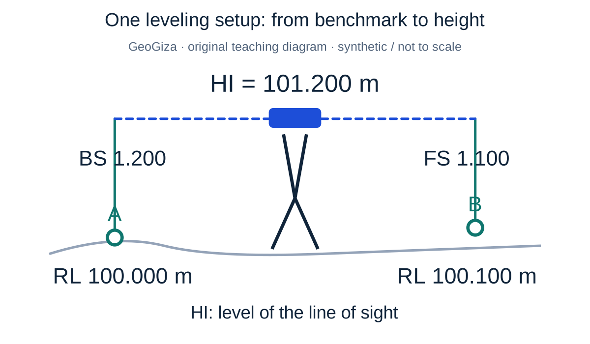
    One leveling setup: from benchmark to height

    Original GeoGiza teaching diagram · synthetic data · not acceptance limits or official approval

    One leveling setup: from benchmark to height

    A synthetic 100.000 m benchmark, 1.200 m backsight and 1.100 m foresight give HI = 101.200 m and RL = 100.100 m. HI is the level of the line of sight, not the physical instrument height above ground.

    HI = 100.000 + 1.200 = 101.200 m; RL = 101.200 − 1.100 = 100.100 m

    A calculated height does not by itself establish the quality or reference ties of the leveling run.

    One setup on a synthetic local reference; not a run-closure example or an acceptance limit.

    Consult this topic’s document locators

    SYNTHETIC teaching example — not field observations or a tolerance limit

    Synthetic review example: ending height

    A known ending height is 100.000 m; the unadjusted computed height is 100.006 m. The arithmetic difference is +0.006 m, or +6 mm. The record omits the work grade and route type.

    What to record in the review

    Record the difference and hold the compliance decision until the grade, length definition and applicable source limit are documented. This example explains a data review, not an Egyptian tolerance limit.

    Mistakes affecting the review decision

    • Using the combined outward and return distance instead of the source’s defined line-length variable.
    • Overwriting raw observations after correction or changing a benchmark without a record.
    • Treating a calculator’s elevation output as route acceptance.

    Official sources and reading locators

    Printed page numbers differ from PDF viewer pages. Open the official link and read the complete provision in the edition applicable to your project.

    Egyptian Survey Authority · Technical reference

    ESA technical specifications — Part I: surveying

    First edition — 2020

    Locator:
    Chapter 2: 3, 3-1, 3-2; table 2-13
    Printed pages:
    33–34
    PDF viewer pages:
    54–55
    Open the authority’s document

    Source checked:

    Source methodology and copyright

    Frequently asked questions

    Does the leveling calculator certify compliance?

    No. It assists elevation arithmetic. Selecting grades, routes and limits, checking observations and approving the work require an identified reference and responsible reviewer.

    Where can I check leveling grades and closure limits?

    In Part I of the ESA specifications, chapter 2 section 3 and table 2-13, printed pages 33–34. Use the edition required for your project and check for official updates.