

When to use this guide
A traverse file should answer three questions: what the network ties to, what was actually observed and how the result was reviewed. Separating observations from corrections prevents a mathematically closed result from hiding weak ties or missing orientation evidence.
The tool’s teaching Bowditch model alone does not establish a least-squares network adjustment or official approval. Check the grade and processing requirements in the source and contract before selecting an adjustment method.
The checklists and examples are original GeoGiza guidance, not specification text, a translation or a compliance certificate. Consult the original document and project scope for applicable grades and mandatory limits.
Edition verified; currentness unconfirmed
Publisher, edition covers and page locators were checked on 11 October 2026. Whether a later official edition supersedes these documents is unconfirmed; check with the responsible authority and the project contract before adopting requirements.
What to prepare before review
- Traverse type, starting and ending control, and known orientations.
- Tie coordinates, reference system, provenance and control checks.
- Angles and distances, units, instrument details and observation sequence.
- Required control grade, processing method and residual report.
Practical review steps
- 1
Map the network connections
Draw the control marks, traverse stations and reference orientation. Check that the computation uses the field record’s leg sequence and angle convention.
- 2
Inspect observations before distributing error
Review repeated observations, instrument records and distance corrections required by the project. Keep rejected readings and the reviewer’s reason; do not delete them to obtain a smaller closure.
- 3
Match the processing method to the requirement
Use the calculator to explore observation effects on closure and Bowditch distribution. If the scope requires least-squares network adjustment, obtain its processing file and report rather than substituting the calculator result.
- 4
Document ties, adjustment and the decision
Collect the network sketch, raw observations, pre- and post-adjustment coordinates, residuals and grade reference. Tie the review outcome to these files and the accepting authority.
Understand the concept visually
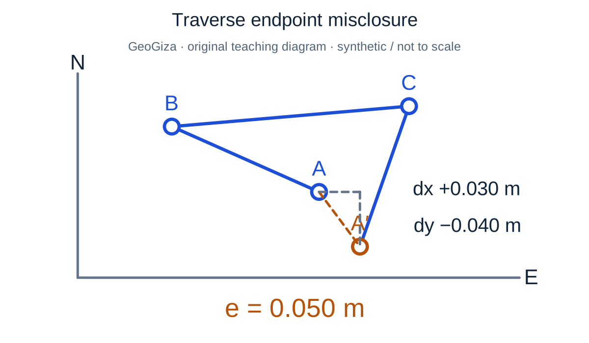
Original GeoGiza teaching diagram · synthetic data · not acceptance limits or official approval
Traverse endpoint misclosure
Endpoint difference means calculated minus reference. In this teaching example dx = +0.030 m and dy = −0.040 m, giving a 0.050 m misclosure. The difference vector is enlarged for visibility.
e = √(dx² + dy²) = 0.050 m; cEᵢ = −dx × Lᵢ / ΣL; cNᵢ = −dy × Lᵢ / ΣL
Misclosure describes a difference; acceptance requires the applicable reference, work grade and observation checks.
cEᵢ and cNᵢ correct the east/north components of each traverse leg; Lᵢ is its length and ΣL the total leg length. Bowditch corrections oppose the misclosure and are proportional to line lengths; distributing them does not prove control-network quality. Not to scale.
Consult this topic’s document locatorsSYNTHETIC teaching example — not field observations or a tolerance limit
Synthetic example: small closure, incomplete evidence
Two files have similar final coordinates. The first preserves raw observations, ties and a processing report; the second provides only corrected coordinates.
What to record in the review
Do not infer equal quality. Request the second file’s observations, adjustment method and grade reference before assessment; similar outputs do not establish valid ties or compliant processing.
Mistakes affecting the review decision
- Mixing internal angles, deflections and azimuths without declaring the convention.
- Checking only linear closure while ignoring orientation, ties and residuals.
- Describing Bowditch correction as ESA approval.
Official sources and reading locators
Printed page numbers differ from PDF viewer pages. Open the official link and read the complete provision in the edition applicable to your project.
Egyptian Survey Authority · Technical reference
ESA technical specifications — Part I: surveying
First edition — 2020
- Locator:
- Chapter 2: 2-2, 2-3, 2-3-1, 2-3-2; table 2-7
- Printed pages:
- 24–26
- PDF viewer pages:
- 45–47
Source checked:
Frequently asked questions
Can one accuracy ratio be used for every traverse?
Do not select it automatically. The source presents grade-specific requirements involving more than one measure; first record the grade, source locator and project requirements.
What is the role of the free traverse log?
It records angles, distances and observation order for practice and review. It is not an approved network adjustment report or official acceptance document.