d is the shorter run in km; the limit checks vertical misclosure.
Limits by work grade. Calculate using the grade named in your project.
Class 0
3 × √D mm
GEOSA · Geodesy · V1.0
Class 1
6 × √D mm
GEOSA · Geodesy · V1.0
Class 2
8 × √D mm
GEOSA · Geodesy · V1.0
Class 3
12 × √D mm
GEOSA · Geodesy · V1.0
D: shorter one-way section length in km. Do not add the forward and return lengths.
Documented editions; currentness and project applicability need confirmation.
I do not know the required grade
Check the contract, quality plan and receiving authority. An unspecified grade leaves project acceptance unresolved; browse and compare limits without an automatically chosen grade.
Rule, formula and evidence register for this task (11)
All rules and evidence are available without JavaScript. Read the complete provision and project conditions.
GEOSA Geodesy · Class 0 · double-run section
3 × √D mm
D: shorter one-way section length in km. Do not add the forward and return lengths.
These are section/loop closure limits, not the height-difference accuracy classification. Consult observation methods, observation corrections and network ties.
Technical Guidelines for Geodesy
General Authority for Survey and Geospatial Information · V1.0 · copyright 2025 · publication date not stated
2.4.2.3 · Table 16 · printed 38 · PDF 38
Copyable official address; direct linking requires publisher permission.
Edition/provision checked: 2026-10-12 · Currentness and project applicability need confirmation.
GEOSA Geodesy · Class 0 · loop
4 × √E mm
E: loop perimeter in km. Do not substitute height-difference accuracy or corrected line-closure aggregates.
These are section/loop closure limits, not the height-difference accuracy classification. Consult observation methods, observation corrections and network ties.
Technical Guidelines for Geodesy
General Authority for Survey and Geospatial Information · V1.0 · copyright 2025 · publication date not stated
2.4.2.3 · Table 16 · printed 38 · PDF 38
Copyable official address; direct linking requires publisher permission.
Edition/provision checked: 2026-10-12 · Currentness and project applicability need confirmation.
GEOSA Geodesy · Class 1 · double-run section
6 × √D mm
D: shorter one-way section length in km. Do not add the forward and return lengths.
These are section/loop closure limits, not the height-difference accuracy classification. Consult observation methods, observation corrections and network ties.
Technical Guidelines for Geodesy
General Authority for Survey and Geospatial Information · V1.0 · copyright 2025 · publication date not stated
2.4.2.3 · Table 16 · printed 38 · PDF 38
Copyable official address; direct linking requires publisher permission.
Edition/provision checked: 2026-10-12 · Currentness and project applicability need confirmation.
GEOSA Geodesy · Class 1 · loop
6 × √E mm
E: loop perimeter in km. Do not substitute height-difference accuracy or corrected line-closure aggregates.
These are section/loop closure limits, not the height-difference accuracy classification. Consult observation methods, observation corrections and network ties.
Technical Guidelines for Geodesy
General Authority for Survey and Geospatial Information · V1.0 · copyright 2025 · publication date not stated
2.4.2.3 · Table 16 · printed 38 · PDF 38
Copyable official address; direct linking requires publisher permission.
Edition/provision checked: 2026-10-12 · Currentness and project applicability need confirmation.
GEOSA Geodesy · Class 2 · double-run section
8 × √D mm
D: shorter one-way section length in km. Do not add the forward and return lengths.
These are section/loop closure limits, not the height-difference accuracy classification. Consult observation methods, observation corrections and network ties.
Technical Guidelines for Geodesy
General Authority for Survey and Geospatial Information · V1.0 · copyright 2025 · publication date not stated
2.4.2.3 · Table 16 · printed 38 · PDF 38
Copyable official address; direct linking requires publisher permission.
Edition/provision checked: 2026-10-12 · Currentness and project applicability need confirmation.
GEOSA Geodesy · Class 2 · loop
8 × √E mm
E: loop perimeter in km. Do not substitute height-difference accuracy or corrected line-closure aggregates.
These are section/loop closure limits, not the height-difference accuracy classification. Consult observation methods, observation corrections and network ties.
Technical Guidelines for Geodesy
General Authority for Survey and Geospatial Information · V1.0 · copyright 2025 · publication date not stated
2.4.2.3 · Table 16 · printed 38 · PDF 38
Copyable official address; direct linking requires publisher permission.
Edition/provision checked: 2026-10-12 · Currentness and project applicability need confirmation.
GEOSA Geodesy · Class 3 · double-run section
12 × √D mm
D: shorter one-way section length in km. Do not add the forward and return lengths.
These are section/loop closure limits, not the height-difference accuracy classification. Consult observation methods, observation corrections and network ties.
Technical Guidelines for Geodesy
General Authority for Survey and Geospatial Information · V1.0 · copyright 2025 · publication date not stated
2.4.2.3 · Table 16 · printed 38 · PDF 38
Copyable official address; direct linking requires publisher permission.
Edition/provision checked: 2026-10-12 · Currentness and project applicability need confirmation.
GEOSA Geodesy · Class 3 · loop
12 × √E mm
E: loop perimeter in km. Do not substitute height-difference accuracy or corrected line-closure aggregates.
These are section/loop closure limits, not the height-difference accuracy classification. Consult observation methods, observation corrections and network ties.
Technical Guidelines for Geodesy
General Authority for Survey and Geospatial Information · V1.0 · copyright 2025 · publication date not stated
2.4.2.3 · Table 16 · printed 38 · PDF 38
Copyable official address; direct linking requires publisher permission.
Edition/provision checked: 2026-10-12 · Currentness and project applicability need confirmation.
When to use this guide
For a Saudi height transfer, build an evidence trail connecting benchmark, vertical reference, observations and result. Record whether the task requires a national-network tie or a local project height; similar numbers do not establish a common datum.
KSA-VRF14 is a vertical reference and KSA-GEOID21 a geoid model. Naming a model does not convert a GNSS height into an accepted project elevation. Our calculator and level book support arithmetic and recording; they do not implement GEOSA’s model or certify a network.
The checklists and examples are original GeoGiza guidance, not specification text, a translation or a compliance certificate. Consult the original document and project scope for applicable grades and mandatory limits.
Edition verified; currentness unconfirmed
Publisher, V1.0, copyright 2025 and page locators were checked on 11 October 2026. The copyright year is not a verified publication date. Currentness and any superseding update remain unconfirmed; check with GEOSA, the receiving authority and the project contract before adopting requirements.
What to prepare before review
Benchmark identifier, condition, description image and height provenance/datum.
Height type: vertical-datum elevation or ellipsoidal height, with units.
Route type, required work grade, length and instrument/staff records.
Raw observations, repeat runs, known ending point and receiving-authority requirements.
Practical review steps
1
Establish the vertical reference first
Tie the benchmark to its height record; label it KSA-VRF14 only when provenance establishes that reference. Keep local heights separate, documenting their zero point and any evidenced network relationship.
2
Review the route before correction
Record raw readings in the level book; check change points, metre units and signs. Compute closure before adjustment, then identify the source provision for the work grade; avoid one generic limit for every route.
3
Separate GNSS measurement from height conversion
If a GNSS height enters the deliverable, request its type, frame, epoch, geoid-model procedure and validation on known points. A subtraction using an assumed value, or relabeling Z as elevation, does not supply that evidence.
4
Deliver the traceability chain
Retain benchmark descriptions, observations, closure report, repeat logs, processing method and reviewer decision. Use the existing handover checklist to distinguish file presence from review completion.
Understand the concept visually
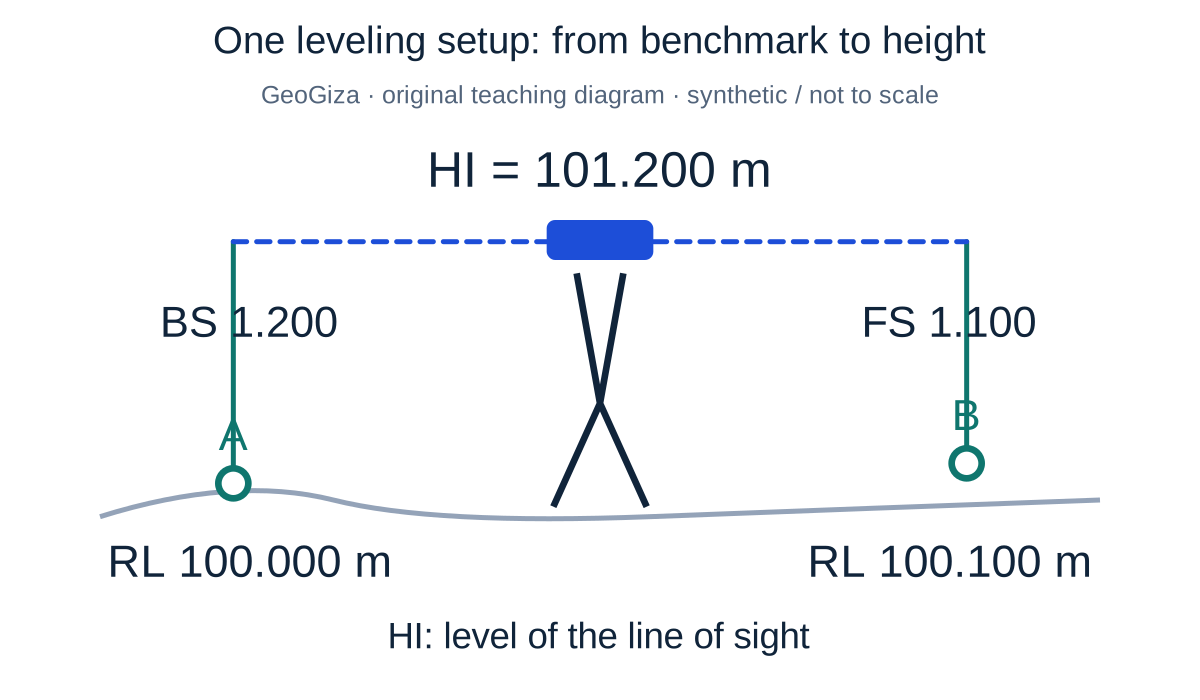
Original GeoGiza teaching diagram · synthetic data · not acceptance limits or official approval
One leveling setup: from benchmark to height
A synthetic 100.000 m benchmark, 1.200 m backsight and 1.100 m foresight give HI = 101.200 m and RL = 100.100 m. HI is the level of the line of sight, not the physical instrument height above ground.
HI = 100.000 + 1.200 = 101.200 m; RL = 101.200 − 1.100 = 100.100 m
A calculated height does not by itself establish the quality or reference ties of the leveling run.
One setup on a synthetic local reference; not a run-closure example or an acceptance limit.
SYNTHETIC teaching example — not field observations or a tolerance limit
Synthetic example: two heights with one label
A GNSS point file lists Z=120.400 m; the project level book lists 98.250 m. Both columns are called elevation, with no height-type or geoid-model record.
What to record in the review
Do not treat the difference as closure error or a ready-made correction. Request both height definitions, benchmark provenance and transformation procedure; preserve each value with its original type until reviewed.
Mistakes affecting the review decision
Labeling an ellipsoidal height as KSA-VRF14 without transformation evidence.
Mixing local and national benchmarks before documenting their relationship.
Treating successful leveling arithmetic as official acceptance of observations.
Official sources and reading locators
Printed and PDF page numbers match in these copies. Source addresses are copyable under the publisher’s linking terms; consult the complete provision in the edition applicable to your project.
General Authority for Survey and Geospatial Information (GEOSA) · Technical reference
Technical Guidelines for Land Surveying
V1.0 · copyright 2025 · publication date not stated
Locator:
2.6.3.2 — leveling
Printed pages:
73–74
PDF viewer pages:
73–74
Publisher document address — copy into your browser:
Does the level book convert GNSS heights to KSA-VRF14?
No. It organizes readings and arithmetic. Height conversion needs a documented reference, model, procedure and the responsible authority’s required validation.
Where should I review leveling grades and routes?
Consult the listed locations in GEOSA’s Land Surveying and Geodesy V1.0 guides, then reconcile their scope with the contract. Tolerance tables are not reproduced and latest-edition status is unconfirmed.