

When to use this guide
Use this decision guide before converting or combining legacy and new survey files. Record the complete coordinate definition; selecting Saudi Arabia or an EPSG code is insufficient when epoch, height reference or transformation method is unknown.
Treat KSA-GRF17, KSA-VRF14 and KSA-GEOID21 as different elements. The existing converter supports projections/CRS definitions and generic parameters for some legacy datums; it does not implement GEOSA’s epoch-aware transformation or KSA-GEOID21. Its numerical comparison badge is not guaranteed field accuracy.
The checklists and examples are original GeoGiza guidance, not specification text, a translation or a compliance certificate. Consult the original document and project scope for applicable grades and mandatory limits.
Edition verified; currentness unconfirmed
Publisher, V1.0, copyright 2025 and page locators were checked on 11 October 2026. The copyright year is not a verified publication date. Currentness and any superseding update remain unconfirmed; check with GEOSA, the receiving authority and the project contract before adopting requirements.
What to prepare before review
- Source/target CRS definitions: frame, epoch, projection, zone and axes.
- Units, height type/provenance and explicitly recorded unknowns.
- Transformation/model procedure, version, approving authority and area of applicability.
- Independent check points, source-data records and output records.
Practical review steps
- 1
Read the file before selecting a CRS
Inspect reference metadata/project records, X/Y order and degree/metre units. If the definition is undocumented, record and request it; coordinate magnitudes alone do not identify a datum.
- 2
Distinguish projection from geodetic transformation
A geographic-to-projected calculation within one reference differs from changing frame or epoch. Use the Saudi systems page and EPSG references to understand definitions, then identify the official procedure required by the task.
- 3
Validate on independent points
Compare output with independent checks of known provenance/reference in the project area. Record difference directions and transformation/version; agreement at one point does not establish performance across the site.
- 4
Deliver source, output and transformation metadata
Preserve the source unchanged alongside output, procedure, reference, epoch and height metadata. Use the existing points template and handover checklist; avoid labeling an unreviewed file approved.
Understand the concept visually
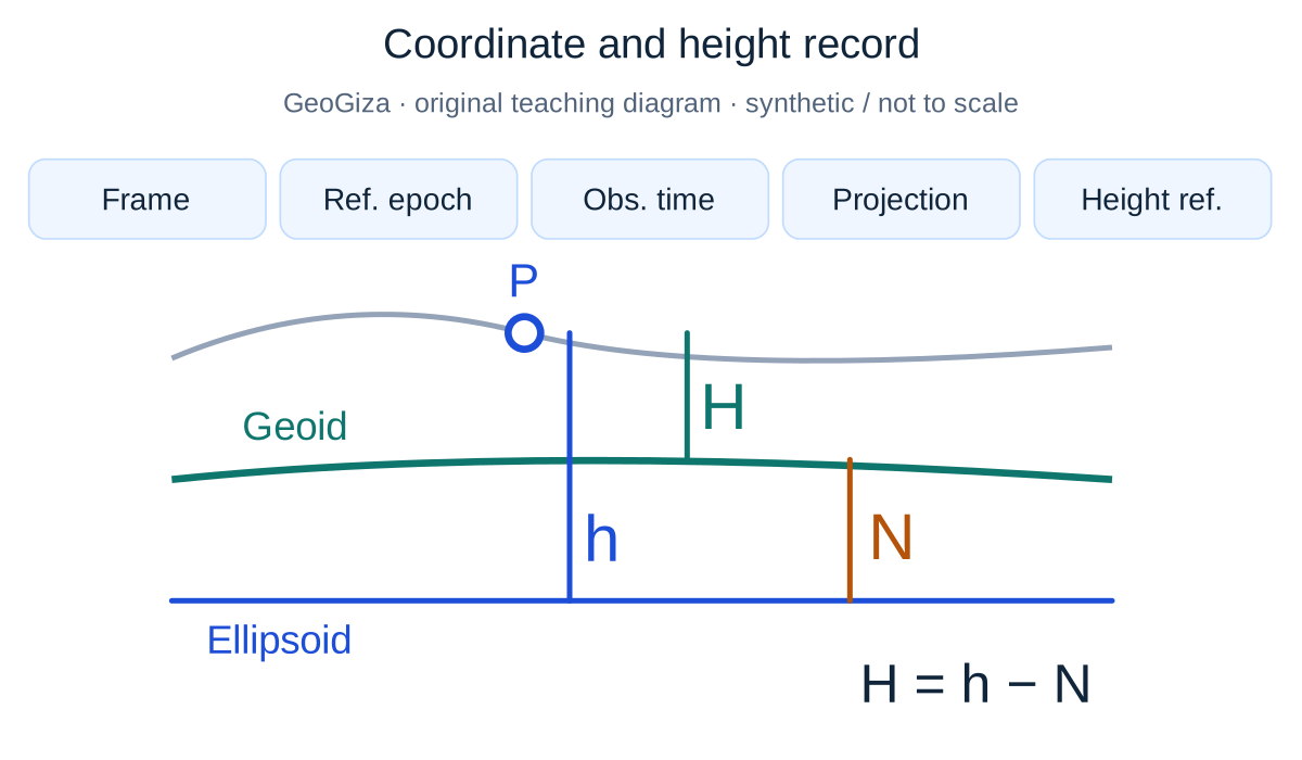
Original GeoGiza teaching diagram · synthetic data · not acceptance limits or official approval
Coordinate and height record
Frame, reference epoch, observation time, projection/zone and vertical reference are independent metadata fields, not automatic transformation steps. In a simplified orthometric case, h is ellipsoidal height, H orthometric height and N the signed geoid–ellipsoid separation.
Orthometric illustration: H = h − N
Projection does not automatically transform the vertical reference; observation time is not necessarily the frame reference epoch.
Not to scale; no geoid value or national-model implementation is shown. This orthometric relationship does not define every type of vertical reference.
Consult this topic’s document locatorsSYNTHETIC teaching example — not field observations or a tolerance limit
Synthetic example: relabeling a reference
A legacy drawing identifies Ain el Abd and a new file KSA-GRF17. Both were relabeled with one CRS without a documented transformation, then appeared to overlap at one point.
What to record in the review
Restore the original definitions and request a transformation procedure, check points and required epoch. Relabeling does not transform coordinates, and visual overlap is not reference evidence.
Mistakes affecting the review decision
- Using the correct zone with the wrong datum.
- Passing Z through without a height definition/datum.
- Treating the tool’s badge as guaranteed national-reference accuracy.
Official sources and reading locators
Printed and PDF page numbers match in these copies. Source addresses are copyable under the publisher’s linking terms; consult the complete provision in the edition applicable to your project.
General Authority for Survey and Geospatial Information (GEOSA) · Technical reference
Technical Guidelines for Land Surveying
V1.0 · copyright 2025 · publication date not stated
- Locator:
- 2.1 — spatial reference; 2.2.3 — references and projections
- Printed pages:
- 11–13
- PDF viewer pages:
- 11–13
Publisher document address — copy into your browser:
https://geoportal.geosa.gov.sa/Geoportal/pdf/Land%20Survey%20Technical%20Guideline.pdf#page=11General Authority for Survey and Geospatial Information (GEOSA) · Technical reference
Technical Guidelines for Geodesy
V1.0 · copyright 2025 · publication date not stated
- Locator:
- 2.2.1–2.2.3 — national geodetic references
- Printed pages:
- 14–15
- PDF viewer pages:
- 14–15
Publisher document address — copy into your browser:
https://geoportal.geosa.gov.sa/Geoportal/pdf/Geodesy%20Technical%20Guideline.pdf#page=14General Authority for Survey and Geospatial Information (GEOSA) · Technical reference
Technical Guidelines for Geodesy
V1.0 · copyright 2025 · publication date not stated
- Locator:
- 2.4.3 — GNSS/leveling
- Printed pages:
- 41–42
- PDF viewer pages:
- 41–42
Publisher document address — copy into your browser:
https://geoportal.geosa.gov.sa/Geoportal/pdf/Geodesy%20Technical%20Guideline.pdf#page=41Source checked:
Frequently asked questions
Does a KSA-GRF17 menu entry mean an official transformation?
No. The definition supports approximate projection calculations; establishing a tie needs coordinate provenance, epoch, transformation procedure and appropriate validation. The official vertical model is not integrated into the tool.
Is the CSV sample automatically suitable for a Saudi project zone?
No. It is synthetic WGS84/UTM 36N data. Replace values with documented project data and specify reference, zone and height; do not merely rename its CRS.