

When to use this guide
Prepare a handover that an independent reviewer can trace. Distinguish file receipt, evidence completeness and acceptance; a readable coordinate file may still have undocumented reference or processing.
GeoGiza’s checklist is a generic organizing template, not a GEOSA form, compliance certificate or substitute for receiving-authority procedures. Identify each work type’s deliverables from reference/contract and retain the reason for every decision or reservation.
The checklists and examples are original GeoGiza guidance, not specification text, a translation or a compliance certificate. Consult the original document and project scope for applicable grades and mandatory limits.
Edition verified; currentness unconfirmed
Publisher, V1.0, copyright 2025 and page locators were checked on 11 October 2026. The copyright year is not a verified publication date. Currentness and any superseding update remain unconfirmed; check with GEOSA, the receiving authority and the project contract before adopting requirements.
What to prepare before review
- Commission scope, receiving-authority requirements and referenced document versions.
- Raw observations, control points, descriptions and provenance.
- Frame, epoch, projection, zone, height type and processing reports.
- File/version register, issues and owners responsible for resolution.
Practical review steps
- 1
Create a work-specific deliverables register
Start with the existing checklist and attach requirements actually applicable to leveling, GNSS, traverse or topographic work. Record source locator and item status, separating received from reviewed.
- 2
Verify data definitions
Compare reference, epoch and height definitions across report/files. Check identifiers, names, units and transformation records; a correctly named file can still have incomplete metadata.
- 3
Review reproducibility
Ensure a reviewer can trace observations, processing and checks to final output. Opening a file or converting its format does not replace missing reports or raw observations.
- 4
Close issues with evidence
Assign each issue an owner, action, due date and evidence file. Preserve delivery version and decision log separately; a deadline does not turn an unknown into an accepted item.
Understand the concept visually
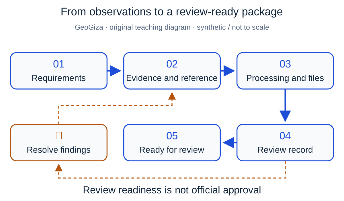
Original GeoGiza teaching diagram · synthetic data · not acceptance limits or official approval
From observations to a review-ready package
Connect requirements with the file register, reference metadata, observations, processing, outputs and review record. Unresolved findings return for correction before the package is submitted for technical review.
Requirements → evidence → findings → technical review
The presence of files does not establish data quality or formal acceptance by the receiving authority.
Teaching workflow: “ready for review” differs from receipt of files, acceptance and official approval.
Consult this topic’s document locatorsSYNTHETIC teaching example — not field observations or a tolerance limit
Synthetic example: files present, report absent
A synthetic package contains CSV, DXF and PDF, but lacks a processing report and clear height reference. All file-presence boxes are checked.
What to record in the review
Record the files as received while processing/height evidence remains outstanding. Keep acceptance separate from file count and tie closure to required evidence.
Mistakes affecting the review decision
- Confusing file presence with technical acceptance.
- Sending adjusted results without observations or processing descriptions.
- Presenting the generic template as an official Saudi approval form.
Official sources and reading locators
Printed and PDF page numbers match in these copies. Source addresses are copyable under the publisher’s linking terms; consult the complete provision in the edition applicable to your project.
General Authority for Survey and Geospatial Information (GEOSA) · Technical reference
Technical Guidelines for Land Surveying
V1.0 · copyright 2025 · publication date not stated
- Locator:
- 2.2.8 — control deliverables
- Printed pages:
- 25
- PDF viewer pages:
- 25
Publisher document address — copy into your browser:
https://geoportal.geosa.gov.sa/Geoportal/pdf/Land%20Survey%20Technical%20Guideline.pdf#page=25General Authority for Survey and Geospatial Information (GEOSA) · Technical reference
Technical Guidelines for Land Surveying
V1.0 · copyright 2025 · publication date not stated
- Locator:
- 2.3.10 — deliverables
- Printed pages:
- 50–51
- PDF viewer pages:
- 50–51
Publisher document address — copy into your browser:
https://geoportal.geosa.gov.sa/Geoportal/pdf/Land%20Survey%20Technical%20Guideline.pdf#page=50General Authority for Survey and Geospatial Information (GEOSA) · Technical reference
Technical Guidelines for Geodesy
V1.0 · copyright 2025 · publication date not stated
- Locator:
- 2.4.1.5 — GNSS deliverables; 2.4.2.6 — leveling deliverables
- Printed pages:
- 37–40
- PDF viewer pages:
- 37–40
Publisher document address — copy into your browser:
https://geoportal.geosa.gov.sa/Geoportal/pdf/Geodesy%20Technical%20Guideline.pdf#page=37Source checked:
Frequently asked questions
Is the existing handover checklist a GEOSA-approved form?
No. It is a free GeoGiza organizing/review template, supplemented by responsible-authority documents and contract requirements.
Where can I find deliverables for each work type?
Use the listed deliverable locations in Land Surveying and Geodesy V1.0, then verify receiving-authority requirements and any later edition; these provisions are not republished here.