The aircraft is the easy part
A survey drone is the most seductive tool in the kit. On our farmland and road jobs it covers in an afternoon what used to take a crew a week on foot, and the imagery looks spectacular on screen. But the orthomosaic and the digital terrain model (DTM) it produces are not measurements — they are interpolations, and they are only as trustworthy as the ground control you tie them to.
The mistake we see most often from teams new to UAV mapping is treating the drone as the source of accuracy. It is not. The aircraft fixes the internal geometry and the scale of the model. Absolute, datum-correct position comes from the survey-grade points you put on the ground. Skip or skimp on those and you get a model that is beautifully self-consistent and quietly, uniformly wrong — the worst kind of error, because nothing on screen warns you.
What our fleet flies into
- 90
- Instruments in the fleet
- GNSS, total stations, scanners, drones
- 1,000+
- Survey projects delivered
- 800,000+
- Feddans levelled
- Where DTM accuracy is everything
- 3,000+
- Km of roads surveyed
- Long corridors that demand strung control
What a GCP is — and what a checkpoint is
A ground control point (GCP) is a precisely surveyed mark on the ground, made visible to the camera with a target, whose coordinates the photogrammetry software uses to anchor the model to your datum and projection. A checkpoint is the same kind of surveyed mark — but you deliberately withhold it from processing. It exists only to test the finished product.
That distinction is the whole game. GCPs steer the adjustment; checkpoints audit it. If you feed every point into the solution you can make the residuals look tiny, but you have measured nothing — you have only proven the software can fit the points you gave it. On our road projects we survey both, on the same control framework, with the same GNSS receivers, before the drone ever leaves the case.
How we survey the targets
We set the control with our GNSS receivers in RTK against a base or network correction, tying into a known datum so the drone block lands in the same coordinate system as the design files. Where a corridor runs long, we leapfrog control down both sides so the centre of the block is never far from a constrained point. Every target is centred, levelled, and logged before it is photographed.
Our GCP-first UAV mapping workflow
- 1
Plan the block and control layout: define the area, target ground sample distance, flight height, and where GCPs and checkpoints will bracket the site.
- 2
Survey the control: occupy each GCP and checkpoint with GNSS (RTK/PPK) on the project datum, centred and logged, recording both horizontal and vertical coordinates.
- 3
Deploy and centre the targets so each is unmistakable in the imagery, sized for the planned flight height.
- 4
Fly the mission with planned forward and side overlap, holding consistent height; capture extra cross-strips over high-relief or featureless areas.
- 5
Process: align images, then constrain the bundle adjustment to the GCPs only — keep checkpoints out of the solution.
- 6
Validate against the withheld checkpoints: compute horizontal and vertical RMSE before exporting anything.
- 7
Generate deliverables — orthomosaic, DTM/DSM, contours — and ship them with the checkpoint accuracy report attached.
Conventional GCP block vs. RTK/PPK drone
| Criterion | Conventional GCP block | RTK/PPK drone |
|---|---|---|
| Ground control needed | Full GCP layout across the block | Few control points, still recommended |
| Independent checkpoints | Required | Still required |
| Field time on targets | Higher — many targets to survey | Lower — fewer targets |
| Robustness to a bad point | High — redundant control | Lower if control is minimal |
| Vertical confidence for a DTM | Strong with good spread | Strong only if checkpoints confirm it |
RTK/PPK trades field effort for reliance on onboard positioning — but checkpoints stay non-negotiable either way.
Why we collect control with GNSS, not the drone alone
How thin control shows up in the deliverable
| Symptom in the model | Likely control cause | Field fix |
|---|---|---|
| Edges of the block tilt or dome | GCPs clustered in the centre, none at the perimeter | Bracket the block — add targets to every edge and corner |
| Whole orthomosaic shifted from design files | Control tied to the wrong datum/projection | Re-survey control on the project CRS and re-constrain |
| DTM good horizontally, off vertically | Too few points with reliable elevations | Add vertical-quality checkpoints; verify GNSS heights |
| Looks great on screen, fails checkpoints | All points used in processing, none withheld | Withhold independent checkpoints and report RMSE |
The patterns we look for first when a block does not validate. · Diagnostics from field practice; accuracy reporting framed per a positional-accuracy standard (asprs-accuracy).
Report accuracy the standards way
We report drone-survey accuracy as horizontal and vertical RMSE computed against independent checkpoints, consistent with a published positional-accuracy standard (asprs-accuracy), rather than quoting a single sensor spec sheet number. A checkpoint-based RMSE is a property of <em>your</em> deliverable on that site — it is what a designer, contractor, or regulator can actually rely on.
From raw imagery to a usable surface
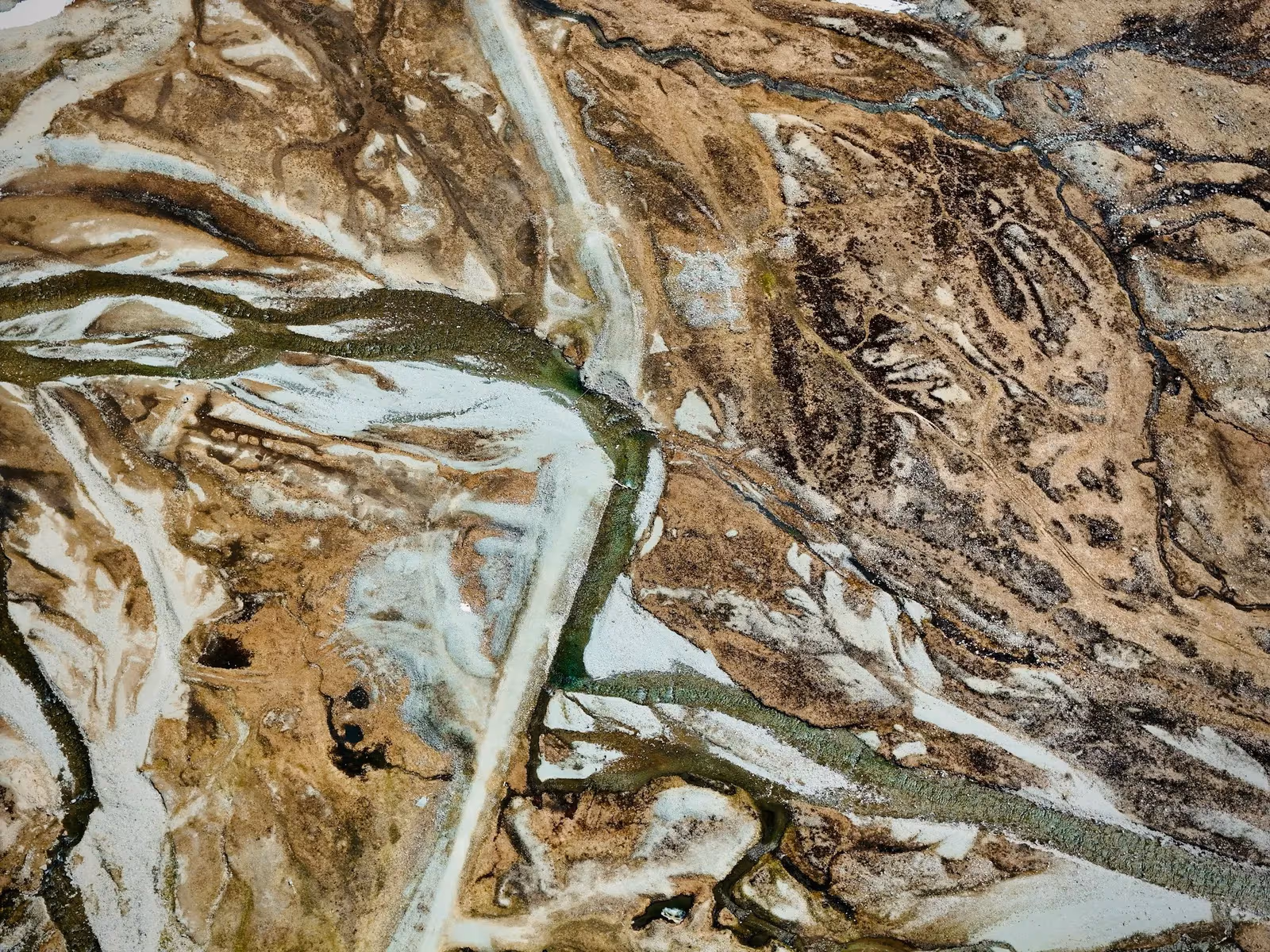 Processed terrain
 Aerial capture
Same ground, two stages: the capture is only data; the controlled, checkpoint-validated surface is the deliverable.
The instruments behind a controlled drone survey
 From our field work
GPS / GNSS / RTK receivers
Survey-grade GPS receivers for centimeter-accurate satellite positioning (RTK) — control, topographic, and cadastral work.
such as Trimble R10/R8, Topcon Hiper V, Leica GS18

Survey drones
UAV photogrammetry and LiDAR for orthomosaics, topographic mapping, and asset inspection.
such as DJI Matrice 300 RTK, Phantom 4
The drone captures; the GNSS receivers establish and check the control that makes the capture measurable.
Go deeper
References
- Survey drone specifications (DJI Matrice / Phantom) — DJI Enterprise
- Positional Accuracy Standards for Digital Geospatial Data (2nd ed.) — American Society for Photogrammetry & Remote Sensing (ASPRS)
- Guidelines for Real-Time Kinematic (RTK) GNSS surveying and geodetic control — US National Geodetic Survey (NGS/NOAA)