A road is a long, thin survey
On the road projects we run, the first thing we tell a new crew member is that a highway is not really a site — it is a corridor. A building site is compact; you can stand in the middle and almost see your whole control network. A road is tens of kilometres long and a handful of metres wide, and that shape changes how you survey it from the first stake to the last as-built. Error that would be invisible on a plot of land has kilometres to accumulate along an alignment, and it always surfaces where two crews working from different ends finally meet.
Over more than 3000 km of roads, the lesson has been the same every time: get the control corridor right and the rest of the job — setting out the alignment, measuring earthworks, checking the as-built — becomes routine. Get it wrong and you spend the project chasing centimetres that never reconcile. This is how our field crews actually do it.
Grounded in road fieldwork
- 3000+
- km of roads surveyed
- 600+
- km of railways
- 90
- instruments in the fleet
- GNSS, total stations, levels, drones
Building the control corridor
Because a road is long and thin, we do not set control as one cluster — we string it down the route as paired points every few hundred metres, with both points of each pair intervisible so a total station can occupy one and backsight the other. Each pair is tied to the national grid, so any crew can re-occupy nearby control at any chainage and stay inside one consistent coordinate frame from start to finish.
We carry those coordinates down the corridor with two instruments doing two jobs. In the open — across fields, embankments, and bridges with clear sky — GNSS-RTK fixes control directly onto the national grid in seconds. The moment the route drops into a cutting, threads under an existing structure, or runs beside a tall obstruction that breaks satellite geometry, we switch to a total-station traverse: a closed chain of angles and distances that carries the RTK coordinates through the shadowed length with line-of-sight precision, and whose misclosure we can check and distribute before trusting it.
Which instrument for which part of the corridor
| Situation | GNSS-RTK | Total station | Drone (photogrammetry) |
|---|---|---|---|
| Open route, clear sky | Primary | Backup | Surface pickup |
| Deep cutting / under structure | Weak signal | Primary | Limited |
| Long open earthwork strip | Slow point-by-point | Slow point-by-point | Fast whole-strip |
| Typical accuracy | ±15–25 mm | ±2–5 mm | Tied to ground control |
| Best role on a road | Corridor control & topo | Traverse & precise set-out | Volumes & as-built strips |
No single tool wins the whole corridor — a real road job hands each one the stretch where it is strongest. Accuracy figures are typical/illustrative.
Setting out the alignment
Once the control corridor is in, setting out is two problems solved at the same chainage. The horizontal alignment is a sequence of straight tangents joined by circular curves and, on higher-speed roads, transition (spiral) curves that ease a vehicle into the turn. The vertical alignment is the profile: the grades that climb and fall, joined by vertical curves over crests and sags. Every peg we drive needs the right easting and northing and the right design level — a station that is perfectly placed in plan but a few centimetres out in height still throws the drainage and the pavement layers.
In practice we compute set-out coordinates from the design model against the same control we established, stake the alignment and offsets, and then independently re-check a sample of pegs from a different control pair. That second occupation is the cheapest insurance on the job: it catches a fat-fingered chainage or a wrong design string long before a machine builds it.
How we survey a road corridor, start to finish
- 1
Reconnaissance: study the design and existing mapping, then drive and walk the route to plan control-pair locations that are stable, intervisible, and clear of construction traffic.
- 2
Tie to the grid: occupy or establish national-grid points and benchmarks so the whole corridor sits on an official datum and a documented coordinate reference system.
- 3
Run the corridor control: fix paired points with GNSS-RTK in the open and a closed total-station traverse through cuttings and under structures, then adjust and check misclosure.
- 4
Survey the existing surface: pick up ground densely where it changes shape — for long open strips fly a drone over set ground targets and build the surface from photogrammetry.
- 5
Set out the design: stake the horizontal alignment, offsets, and vertical levels from the design model, independently re-checking a sample from a second control pair.
- 6
Measure earthworks and as-built: compare existing, design, and as-built surfaces to compute cut/fill, and re-survey after each major phase against the same control.
Earthworks: where the money is measured
On most road contracts, the largest single quantity — and the one that draws the most scrutiny — is earthworks: how much material is cut away and how much fill is placed. A volume is never measured directly; it is the difference between two surfaces. We survey the existing ground densely enough to model its real shape, compute cut and fill against the design surface, then re-survey after each major phase so progress is measured against the same control rather than against a fresh, slightly different frame each month.
The risk in a volume is almost never the arithmetic — it is the surface model. A surface built from points spaced too far apart smooths over the very dips and crests that hold the volume, so we densify wherever the ground changes shape and let the drone carry the long, uniform strips. The number that ends up on the payment certificate is only as honest as the surface behind it, which is why we document the method, the control, and the survey density for every quantity we hand over.
Where a corridor coordinate's error typically comes from
Control is re-checked, never assumed
Before set-out and before each earthwork measurement, we re-confirm the base coordinate and the benchmark our levels run from, and our total stations are checked against established field procedures. On a corridor this matters more than anywhere: a stale base coordinate or an out-of-adjustment instrument does not announce itself — it quietly biases an entire kilometre of alignment and every volume tied to it until someone re-occupies known control. Per the practice the FIG promotes internationally, 'accurate' has to be a documented, re-checkable claim, not a hope.
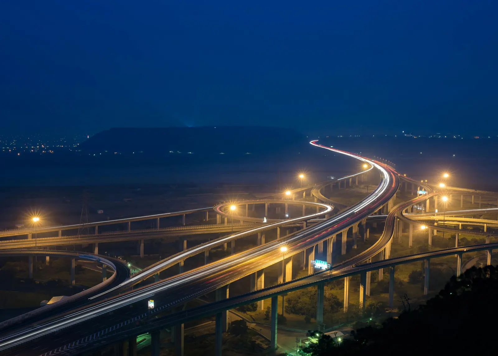
A highway corridor from the air
The instruments behind a road corridor
 From our field work
Total stations
Survey instruments for precise angle and distance measurement — control networks, layout, and as-builts.
such as Leica TS16, Viva TS, Topcon ES-series
 From our field work
GPS / GNSS / RTK receivers
Survey-grade GPS receivers for centimeter-accurate satellite positioning (RTK) — control, topographic, and cadastral work.
such as Trimble R10/R8, Topcon Hiper V, Leica GS18

Survey drones
UAV photogrammetry and LiDAR for orthomosaics, topographic mapping, and asset inspection.
such as DJI Matrice 300 RTK, Phantom 4
GNSS-RTK for open-route control, total stations for traverse and precise set-out, drones for long-strip surfaces and volumes — the mix every road job draws on.
Take it further
References
- Guidelines for Real-Time Kinematic (RTK) GNSS surveying and geodetic control — US National Geodetic Survey (NGS/NOAA)
- International Federation of Surveyors publications on professional and cadastral standards — International Federation of Surveyors (FIG)